As Ohio voters head to the polls next week, many will struggle to overcome congressional districts that have allowed politicians to choose their voters instead of the other way around.
Thanks to an aggressive redistricting operation, Ohio’s current congressional map, enacted in December 2011, is gerrymandered to lock in a 12-to-4 district advantage for Republican candidates.
In each subsequent election, it has worked according to plan: In 2012, Republican candidates earned 51 percent of the statewide vote, but secured 75 percent of the state’s congressional seats. In 2014, they earned 59 percent of the vote, but held onto 75 percent of the seats. In 2016, the Ohio GOP took 57 percent of the vote, and — yet again — kept 75 percent of the Congressional seats.
In May, the ACLU challenged Ohio’s gerrymandered map as a violation of voters’ constitutional rights, seeking to replace it with a new one before the 2020 election.
In our lawsuit, APRI v. Smith, we submitted a new proposed congressional map, drawn by our expert, Bill Cooper — who has drawn maps in about 750 jurisdictions across 45 states, primarily on behalf of plaintiffs represented by civil rights organizations.
Our proposed map improves the existing one every way.
Here’s how:
It undoes the extreme “packing” and “cracking”
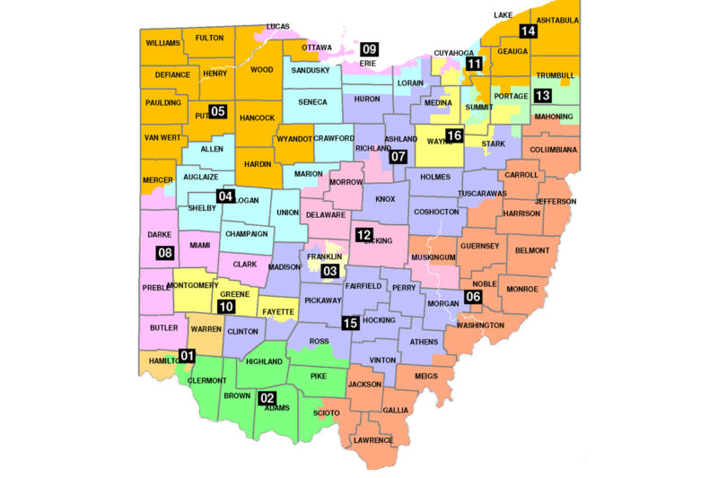
A side-by-side comparison of the two maps shows stark differences. Whereas Ohio’s current map has multiple irregularly shaped, barely contiguous districts, the new map is more compact and splits fewer counties and cities.
Look at the top right (Districts 7, 9, 11, 13, 16) and the bottom left (Districts 1, 2), for easy points of comparison. Note there is no more “Snake on the Lake,” as District 9 is often labeled, because of how it ingests portions of five counties while containing none in their entirety.
Current Ohio Map:
Proposed Ohio Map:
Gerrymandering is primarily achieved by either “packing” — overconcentrating a particular class of voters in a district in order to diminish their efficacy in other districts — or “cracking,” the practice of splitting up a particular class of voters so that they are unable to band together and see their will reflected in their elected representatives.
The differences are most dramatic around Ohio’s cities, where more voters who support Democrats tend to live. Currently, these population centers and surrounding areas are sliced up in various ways, so that pieces of the same city lie within different voting districts, and/or are packed together, so that their reach is limited to a single district.
For example, Cincinnati is cracked across Districts 1 and 2 of the current map. Our proposed map would make the city whole.
Current District 1 Map:
New District 1 Map:
The same is true in Northeast Ohio. Cleveland and Akron are both cracked apart, and then half of each is packed into a single district, District 11.
The remaining portion of Cleveland is then packed into District 9 — the “Snake on the Lake” — with the city of Toledo. And the other half of Akron is packed into a district with the city of Youngstown.
One of our plaintiffs, Chitra Walker, lives in Lakewood, a city that is part of the Cleveland area in District 9. Instead of belonging to the same district as others living in Cleveland, she shares a district with people living in Toledo, which is 108 miles away. This contorted construction ensures that regardless of changes in voter preference across election cycles, Democrats are limited to prevailing in the same four districts each cycle.
Current District 11 Map:
New District 11 Map:
In May, Ohio voters overwhelmingly approved Issue 1, a ballot initiative that seeks to reform how congressional maps are drawn going forward. It puts a limit on the number of cities and counties that can be split and sets out other redistricting criteria, including making districts more compact.
Ohio’s current congressional map splits 23 counties, while our proposed plan splits just 14. The current map splits both Cincinnati and Cleveland, while our proposed plan keeps them whole. And it is not just the big cities: The current map splits 73 cities, towns, and villages, while our proposed map splits only 27.
It better complies with the Voting Rights Act
The map is also better under the Voting Rights Act, which guarantees that minority voters have a chance to have their voices heard and votes counted. In the context of redistricting, it protects minority voters against plans that dilute their voting strength, which is mainly done in two ways. The first is by submerging minority voters in a district where they do not have the opportunity to elect candidates of their choice. The second is by packing, or concentrating, minority voters into one district in order to limit the number of places where these voters can impact elections.
In creating our map, we had one of our experts conduct “racially polarized voting analysis.” This is the analysis used in the context of the Voting Rights Act to determine what minority voting age population is needed to ensure that minority voters have the opportunity to elect their candidates of choice. Setting the minority voting age population below this threshold would demonstrate vote dilution achieved by the first of the two methods described: submerging minority voters. Setting the minority voting age population substantially above this threshold would demonstrate the second: overpacking of minority voters in one district.
Our analysis found that in order for Black voters in northeastern Ohio to have the opportunity to elect their candidates of choice, they needed to make up above 45 percent of the voting age population in District 11.
Currently, Black voters comprise over 52 percent of the voting age population in District 11, where they are overconcentrated. The map drawers never did the necessary analysis before overpacking black voters into District 11.
In our proposed map, District 11 would retain a Black voting age population of about 47 percent. That means it would address the excessive packing of Black voters into District 11, but still ensure that these voters have the opportunity to elect their candidates of choice — thus ensuring the protection of these voters, as required by the Voting Rights Act.
It is responsive to the will of voters
Instead of the consistent 12-4 split, which gives Republicans 75 percent of the seats despite getting just over 50 percent of the vote, the new map allows for electoral results that actually change based on voters’ choices. In fact, it encourages it — by creating districts previously designed to be forgone conclusions to become newly competitive.
Tracking the 2012 and 2016 congressional results across the new districts shows how. When you project the votes from the 2012 election across our proposed map, a Democrat would have been elected in 6 districts and Republicans in 10. Two of those 10 Republican seats would have been competitive, projecting Democratic vote totals of 48.5 and 48.6 percent in each. And in 2016, when Democrats took fewer votes statewide, the outcome using the new map also shifts, to an 11-5 Republican to Democrat split, with two of the 11 seats being competitive.
The answer to partisan gerrymandering is not to allow the opposite political party to gerrymander instead. It is to create districts that reflect and respond to voters’ choices. There are clear, neutral ways to do that.
View your district on Ohio’s current map and our proposed one.
Related Issues
Related Content
-
Press ReleaseJun 2026

Voting Rights
Supreme Court Protects Mail Voting And Preserves States’ Authority Over Ballot Receipt Rules. Explore Press Release.Supreme Court Protects Mail Voting and Preserves States’ Authority Over Ballot Receipt Rules
WASHINGTON, D.C. — Today, the Supreme Court issued a decision upholding voters’ rights and permitting Mississippi voters’ ballots that are cast on time to be counted after Election Day according to state law. The decision reverses the Fifth Circuit’s incorrect interpretation of federal Election Day statutes, which would have invalidated decades-old absentee ballot receipt laws and disenfranchised voters who followed all election rules but faced postal delays beyond their control. The American Civil Liberties Union and ACLU of Mississippi, on behalf of the League of Women Voters, Rural Coalition/Coalición Rural, Center for Rural Strategies, American Association of People with Disabilities (AAPD), and Disability Rights Mississippi (DRMS), filed an amicus brief arguing that the Fifth Circuit’s decision would have disrupted states’ ability to determine mail-ballot receipt rules in their own state and depending on the needs of their voters and disproportionately harmed voters with disabilities, rural voters, older voters, military and overseas voters, and working people who rely on absentee voting. The coalition released the following statement: “This decision protects the fundamental principle that people should not lose their right to vote because of mail delays outside their control. The Court recognized what states, Congress, and voters have understood for generations: federal law does not require states to discard timely-cast ballots simply because they arrive after Election Day. Today’s ruling preserves critical protections for voters with disabilities, rural communities, older voters, working families, and countless Americans who depend on absentee voting to participate in our democracy.” The organizations emphasized that the ruling preserves states’ flexibility to administer elections in ways that reflect local realities and protects longstanding election practices relied upon by voters nationwide. Read the Court's ruling here: https://www.supremecourt.gov/opinions/25pdf/24-1260_g3cn.pdf -
Press ReleaseJun 2026
Voting Rights
Voting Rights Groups Applaud Ruling Declaring 2026 Executive Order Interference With Voter Rolls And Mail-in Ballots Unconstitutional And Unlawful. Explore Press Release.Voting Rights Groups Applaud Ruling Declaring 2026 Executive Order Interference with Voter Rolls and Mail-In Ballots Unconstitutional and Unlawful
BOSTON — A federal court today declared unconstitutional key portions of President Trump’s executive order restricting mail voting. The executive order, issued in March 2026, unlawfully attempted to seize control of elections by ordering the Department of Homeland Security to compile a list of U.S. citizens and by directing the U.S. Postal Service to restrict mail voting. The decision came in a case brought by 23 states and the District of Columbia, led by California. The court declared that Sections 2 and 3 of the executive order are legally void and barred federal agencies from using the executive order as a basis to interfere with how plaintiff states maintain their voter rolls or conduct mail voting. The court’s ruling also blocked the U.S. Postal Service from withholding mail ballots from voters not on an approved list in the plaintiff states. The court is also considering a separate legal challenge to the executive order brought by a coalition of nonpartisan voting rights groups in the case LWVMA, et al., v. Trump, et al. That suit was filed by the League of Women Voters of Massachusetts, the League of Women Voters, Association of Americans Resident Overseas (AARO), U.S. Vote Foundation, OCA - Asian Pacific American Advocates (OCA), and Delta Sigma Theta Sorority, Inc. They are represented by the American Civil Liberties Union (ACLU), ACLU of Massachusetts, Brennan Center for Justice, Legal Defense Fund (LDF), Asian Americans Advancing Justice - AAJC (Advancing Justice - AAJC), and LatinoJustice PRLDEF. Attorneys and plaintiffs in the voting rights group case issued the following joint statement: “As this ruling makes clear, President Trump’s executive order from March 2026 attempting to seize control of elections is unconstitutional and dangerous. “This ruling is a critical step in preserving free and fair elections. The court rightly recognized that the President and the executive branch lack both the legal authority and the capacity to compile a complete and accurate list of U.S. citizens or eligible voters in every state. The ruling also rightly recognizes that the U.S. Postal Service has no authority to limit the distribution of mail ballots. “The court has yet to rule on our request to block the executive order’s provisions on mail voting on behalf of a nonpartisan coalition of voting rights groups. The same reasoning underpinning today’s decision should hold in our case. President Trump’s unlawful executive order violates the separation of powers, threatens the integrity of our elections, and must be enjoined from taking effect in the upcoming primary and midterm elections.” -
Press ReleaseJun 2026
Voting Rights
Aclu Launches Historic Election Safeguarding Effort Ahead Of The Midterms. Explore Press Release.ACLU Launches Historic Election Safeguarding Effort Ahead of the Midterms
WASHINGTON — In 2026, the ACLU will be at the forefront of ensuring all eligible voters can cast their ballot—making its largest ever investment in election safeguarding during a midterm cycle. Bolstered by the combined power of our storied legal, policy, and advocacy expertise, affiliate presence in every state, and network of millions of volunteers and supporters, the ACLU will spend $24.5 million to protect the power to vote, the resilience of our democratic institutions, and public confidence in every stage of the electoral process; and to guarantee that every vote is counted according to the law. Drawing on lessons and analysis of recent election cycles, the ACLU has identified potential threats across 25 scenarios to voting access, election administration, and certification, and stands ready to take swift legal, advocacy, and organizing action to protect voters and defend our democracy throughout the 2026 midterms and beyond. Our election safeguarding work will strengthen the state and local institutions that are the backbone of free, fair, and trusted elections in the United States, ensuring they can operate independently, professionally, and free from improper interference. Fueled by the power of the ACLU’s nationwide affiliate network, these efforts will include preparing thousands of volunteers for poll and post-election monitoring, leading Know Your Rights trainings, hosting get-out-the-vote activations, organizing mass mobilization efforts, coordinating local rapid response campaigns, and taking swift legal action in the courts when necessary to ensure that all American voters can cast their ballots and have their votes counted. In addition to these nationwide tactics, the organization will also surge national staff into priority states, including additional organizers who have already been deployed in Arizona, Georgia, North Carolina, and Pennsylvania, where the risk of election interference and voter disenfranchisement is high. “In a democracy, every eligible voter has the right to vote freely and the outcome respected,” said Deirdre Schifeling, ACLU Chief Political and Advocacy Officer. “Our right to vote is facing a coordinated attack on multiple fronts. But in a democracy, people choose their politicians, not the other way around. When access to the ballot is restricted and the results of elections are not respected, the very foundation of our democracy hangs in the balance. That is why the ACLU is launching the largest ever election safeguarding program in our century-long history. Our powerful network of thousands of staff and millions of supporters will work tirelessly in states nationwide to ensure that every voter can cast their ballot without intimidation and that the results are honored. The best way to protect our freedom is to act free—the ACLU will be in communities making sure all voters can do just that." Already this election year, the ACLU legal team and its partners have taken legal action in more than two dozen states and Washington, D.C. to protect voting rights. They are currently advancing over 80 legal actions challenging discriminatory voting laws, racial gerrymandering, attacks on mail voting and voter registration, and other efforts to undermine free and fair elections. Since the Supreme Court’s disastrous Callais decision in April, the ACLU and its partners have been hard at work to preserve and restore voting rights and representation across the country and will continue to meet these threats to our elections in court. “Election Day is one day; the fight for the franchise is every day. We’re witnessing an onslaught of tactics by anti-democracy policymakers who want to make it harder to vote, easier to discriminate against voters of color, and stymie the will of the people,” said Sophia Lin Lakin, Director of the ACLU’s Voting Rights Project. “We’re already in the thick of litigation to champion voters’ rights around the country, and we are preparing for more fights as November approaches. Suppress votes, rig the rules, or undermine election results--and you’ll see us in court.” Against the current landscape of unprecedented abuses of authority and concerted attempts at voter suppression — especially the attempts to silence Black voters—the ACLU’s Midterm Election Safeguarding Program stands as an ambitious, strategic, multi-state effort to ensure that voters choose their elected representatives, not the other way around. By deploying the collective power of its litigation, organizing, and advocacy tools, the ACLU is prepared to ward off attempts to subvert our democracy across the country. -
Press ReleaseJun 2026
Voting Rights
Federal Court Rejects Doj Attempt To Obtain Maryland’s Sensitive Voter Data. Explore Press Release.Federal Court Rejects DOJ Attempt to Obtain Maryland’s Sensitive Voter Data
ANNAPOLIS, Md. — A federal court today rejected the U.S. Department of Justice’s attempt to force Maryland election officials to turn over the state’s unredacted voter registration file, protecting the sensitive personal information of millions of Maryland voters. The ruling is the ninth rejection by courts of the DOJ’s nationwide campaign to obtain states’ voter registration databases, including voters’ dates of birth, residential addresses, driver’s license numbers, and partial Social Security numbers. The court found that federal law does not authorize the government’s sweeping demand for Maryland’s confidential voter data. The case, United States v. DeMarinis, arose after the DOJ sued Maryland in December 2025 seeking access to the state’s complete voter file. The lawsuit was part of a broader effort by the DOJ to obtain similar records from states across the country despite significant privacy concerns and the absence of clear congressional authorization for such a database. Maryland voters, Common Cause, and Out for Justice, Inc, intervened in the case, represented by the American Civil Liberties Union and ACLU of Maryland, to defend voters’ privacy rights and challenge the federal government’s unprecedented request. “Martin Luther King Jr. once said the greatest march an American can take in a democracy is a march to the ballot box. Today’s decision reaffirms that this march is essential, and that no administration can place obstacles in the path of those who choose to take it,” said Carl Snowden, a voter intervenor and convener of the Caucus of African American Leaders. “Today’s ruling is a massive victory for voter privacy and a rejection of federal overreach. The decision ensures voters are protected from an unauthorized national database that would have been a goldmine for hackers and a tool for intimidation. Our elections remain safe, secure, and in the hands of Marylanders where they belong,” said Joanne Antoine, Common Cause’s Maryland Executive Director. The remaining counsel and plaintiff organizations released the following joint statement: “This is a victory for every Marylander who wants to participate in democracy without fear. The DOJ sought access to some of the most sensitive information Maryland voters possess while refusing to explain why it needed that data or what it planned to do with it, in an effort to intimidate eligible voters and build an unprecedented and unlawful national voter database. We will continue fighting efforts by the federal government to weaponize voter data that threatens voter privacy, chills participation, and undermines trust in our democracy.” Read the court’s order dismissing the DOJ’s lawsuit here: https://assets.aclu.org/live/uploads/2026/06/91-DeMarinis-Dismissal-Order.pdf